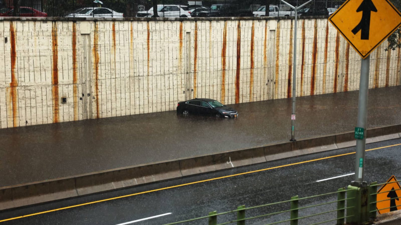
Heavy rain and flooding on Friday making for an extremely challenging and dangerous Friday morning commute and led to subway and rail service suspensions and the closure of a terminal at LaGuardia Airport.
Forecasts are reinforcing the potential for heavy rain centered around the NYC area from Friday into Saturday morning. A flood watch is in effect through 6 a.m. Saturday for the entire tri-state, with rainfall rates of 1-2 inches per hour expected at times. Throughout the region, at very least 2-4 inches can be expected, while some areas can expect to see between 5-8 inches before the storms move on.
Parts of New York City have already seen five inches of rain as of 11 a.m.
Flash flood warnings were issued for much of NYC and surrounding counties in New Jersey, the Hudson Valley and into Connecticut into the early afternoon, and were likely to be extended further.
New York Gov. Kathy Hochul declared a state of emergency for the areas impacted.
“I am declaring a State of Emergency in New York City, the Hudson Valley and Long Island in response to the significant, dangerous rainfall that is currently impacting the region and is expected to continue for the next 20 hours,” Hochul said in a statement. “Ahead of this storm we deployed thousands of State personnel and I have directed all State agencies to provide all necessary resources to address this extreme weather event. It is critical that all New Yorkers take all necessary precautions and avoid flooded roads, which are some of the most dangerous places during flash floods.”
Bouts of heavy rain made morning commute nightmarish and conditions only continued to worsen; it will be even more widespread throughout the afternoon and evening. Flooding is possible for much of the tri-state area as a result of the heavy rain, which comes as the ground is already water-logged due to the remnants of Ophelia that drenched the region last weekend.
As for rainfall amounts, much of the New York City area (including the five boroughs) will likely see 2-4 inches by the time the storm moves on. Places that could see more than that include parts of Ocean and Monmouth counties along the Jersey Shore, as well as isolated spots in the Hudson Valley, where anywhere from 4-8 inches of rain could fall. Other spots may see lower amounts, only about an inch or two, like on eastern parts of Long Island and some parts of New Jersey.
Again, due to last weekend’s four days of consistent rain saturating the soil, getting that much precipitation so quickly is more than enough to create serious flooding and flash flooding conditions.
MTA suspends several subway lines, warns of ‘extremely limited’ services
The MTA began making preparations for the storm on Thursday, and Chairman Janno Lieber said that the system “would be running” throughout the storm, but did add that interruptions were possible in particularly problematic spots that are prone to flooding. LIRR would have additional staffing on as well in order to quickly address any problems.
Lieber said it’s possible that some bridges could be shut down, depending on wind and rain conditions.
A number of subway lines were suspended on Friday morning with other lines suspending service through flooded stations, especially in Brooklyn.
Coastal zones will once again be at risk, continuing a brutal run for places like the Jersey Shore. It’s been day after day of gusty winds, rough surf and higher high tides, and unfortunately coastal flooding will be a concern once more.
A full moon won’t help with tide levels, which will lead to the chance for minor coastal flooding. Rough surf will ensure additional beach erosion as well.
Severe storms with damaging wind, hail and tornadoes are not expected; it just appears to be rain, though a whole lot of it.
NYC issues travel advisory for Friday and Saturday
The city enacted a flash flood plan and will have crews inspecting catch basins and roads in areas prone to flooding.
New Jersey Gov. Phil Murphy reminded resident to be careful and never drive or walk through flooded roads.
“I have directed my team to prepare for the storm and coordinate in advance with county and local officials,” Murphy said in a statement.
In Hoboken, Mayor Ravi Bhalla warned residents to take precautions.
“The City of Hoboken is preparing for what is expected to be a substantial storm with prolonged periods of heavy rainfall, which will likely cause flooding in low-lying areas of Hoboken,” Bhalla said in a statement. “I encourage residents, especially those in garden level apartments, to take precautions ahead of the storm. I also encourage residents and visitors to avoid driving during periods of peak rainfall when possible. While our flood pumping stations are in operation and our resiliency parks are positioned to store water to the greatest extent possible, the prolonged severity of the weather could outpace the capacity of our infrastructure to keep rainwater off streets.”
NYC Public Schools plan to remain open on Friday
New York Public Schools announced schools will remain open on Friday and encouraged students and staff to allow for extra time.
The Mets vs. Phillies game at Citi Field on Friday was postponed and will be played as part of a doubleheader on Saturday.
So how long will the rain and nasty conditions stick around this time? Luckily it won’t be nearly as long, though it will linger into Saturday morning. The showers stop around then and the rest of the weekend looks pleasant — particularly Sunday, which is expected to feature sunny skies and temperatures in the mid 70s.
After that, warmer and rain-free weather will dominate the week. Temperatures stay in the mid 70s, although Tuesday could see highs around 80s degrees — a blast of summer-like feels during the first week of October.
Read the full article here